- Free State Online
- Departments
- Office of the Premier
- Agriculture & Rural Development
- Education
- Health
- Coorporative Governance & Traditional Affairs
- Public Works & Infrastructure
- Police, Roads & Transport
- Social Development
- Sport, Art, Culture and Recreation
- Economic, Small Business Development, Tourism & Environmental Affairs
- Human Settlements
- Treasury
- Municipalities
- Entities
Towns
BETHULIE
Overview
Bethulie/ Lephoi serves as a regional agricultural service centre within Kopanong Municipality and is situated approximately 52 km south of Trompsburg and about 185 km from Bloemfontein. Access to the town is gained from the R701 route between Gariep Dam and Smithfield.
Social and economic functions
The main social and economic function of the town is to serve as (a) key regional destination, (b) secondary agricultural service centre, and (c) social functions such as residence, education and medical services.
HISTORICAL AND TOURISM INFORMATION
Bethulie and its surrounds are rich in history. Second only to the environment, history is what makes the area worth visiting.
Fossils
Fossils as old as 260 million years have been found, including Procolophon, Lystrosaurus, Proterosuchus, Lydekterina and Thrinaxodon. There are also remains of an ancient lake 230 million years old.
Before the missionaries
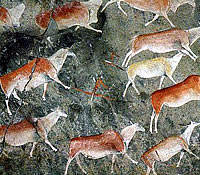
RJ Gordon reached the Groot Rivier about 10 km west of the present Bethulie and renamed it the Orange River. In 1803 Governor JW Janssens travelled to this area and in 1809 Colonel Richard Collins reached the confluence of the Caledon and Orange Rivers where he gave the Caledon its western name. Nomadic farmers were visitors to the region in 1820 already. The Bushmen were the first inhabitants of the area. RJ Gordon made sketches in 1777 where he noted seeing six Bushmen in the vicinity of where the northern point of the Steyn bridge is now. A considerable number of Bushmen paintings can be seen in the region.
Missionary era
James Clarke and GA Kolbe of the London Missionary Society did missionary work among the Bushmen from 1828-1833. JP Pellissier of the Paris Missionary Society did similar work from 1833-1867 among the Batlhapin who had followed him from Zeerust. Their captain was Lephoi.
Founding of the town
A dispute erupted between Pellissier and Lephoi after the latter sold the ground of the mission station to migrant farmers. A syndicate of migrant farmers bought the ground in 1860 and acquired 6000 morgen for the establishment of a town. In 1863 the town was proclaimed under the name of Heidelberg.
Anglo Boer War
The first participation of Bethulie burghers was in the Battle of Stormberg on 10 December 1899. The Boers blew up the train bridge across the river in 1900. Three burghers died in the skirmish at the old wagon bridge on 10 March 1900. The British occupied Bethulie in 15 March and placed the town under military control. The concentration camp began in April 1901 just outside the town where between 4800- 5000 people were contained. In the following 13 months 1714 women and children died there. The cemetery displays small sandstone graves of deceased concentration camp children to the silver crosses at the heads of soldiers’ graves. A large memorial, built on the outskirts of town, with name walls will have you linking a trace to the many nationalities once engulfed in the duress of the Anglo Boer War.
San Rock Art
San Rock art in the district, less than 20km from Bethulie, gives evidence of the early San in the area, while the movements of the Voortrekkers, and the strife of numerous wars can be seen all over area.
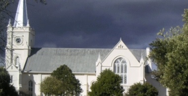
D.H Steyn Bridge: A beautiful sandstone bridge near the town. It is the longest road and rail bridge at 1,2km in the country. Dutch Reformed Church: A stately edifice, completed in 1887 and now a national monument.Grave of JJ Venter: Former acting President of the Free State Province. Horse Memorial: The memorial is a tribute to horses and their courage on the battlefield.
Klaversfontein Rabbit Farm:15km Outside Bethulie, angora fur production can be viewed. Louw Wepener Memorial: Wepener, who led Free State commandos in the second of the Basotho Wars, is honoured in this memorial 10km north of the town. Ox-wagon Monument: A tribute to the Voortrekker’ mode of transport. The building of the Gariep dam: The building of the Gariep dam and the establishment of the Tussen-die-Riviere game reserve was far-reaching as the town of Bethulie lost 60% of its land area. The dam was completed in 1971. The railway had to be moved. The old road and rail bridges had to be dismantled. The old station, built in 1894, had to be closed and a new station at the opposite end of town had to be built in 1970.
Facts About Bethulie
Bethulie is a small, historical town in the southern Freestate province on the northern banks of the Gariep Dam, about 90 minutes drive (185Kms) from Bloemfontein. Bethulie serves a cattle and sheep farming area.
Historical and tourism information
Bethulie and its surrounds are rich in history. Second only to the environment, history is what makes the area worth visiting. Fossils as old as 260 million years have been found, including Procolophon, Lystrosaurus, Proterosuchus, Lydekterina and Thrinaxodon. There are also remains of an ancient lake 230 million years old.
Before the missionaries
RJ Gordon reached the Groot Rivier about 10 km west of the present Bethulie and renamed it the Orange River. In 1803 Governor JW Janssens travelled to this area and in 1809 Colonel Richard Collins reached the confluence of the Caledon and Orange Rivers where he gave the Caledon its western name. Nomadic farmers were visitors to the region in 1820 already. The Bushmen were the first inhabitants of the area. RJ Gordon made sketches in 1777 where he noted seeing six Bushmen in the vicinity of where the northern point of the Steyn bridge is now. A considerable number of Bushmen paintings can be seen in the region.
Missionary era
James Clarke and GA Kolbe of the London Missionary Society did missionary work among the Bushmen from 1828-1833. JP Pellissier of the Paris Missionary Society did similar work from 1833-1867 among the Batlhapin who had followed him from Zeerust. Their captain was Lephoi.
Founding of the town
A dispute erupted between Pellissier and Lephoi after the latter sold the ground of the mission station to migrant farmers. A syndicate of migrant farmers bought the ground in 1860 and acquired 6000 morgen for the establishment of a town. In 1863 the town was proclaimed under the name of Heidelberg.
Anglo Boer War
The first participation of Bethulie burghers was in the Battle of Stormberg on 10 December 1899.The Boers blew up the train bridge across the river in 1900. Three burghers died in the skirmish at the old wagon bridge on 10 March 1900. The British occupied Bethulie in 15 March and placed the town under military control. The concentration camp began in April 1901 just outside the town where between 4800- 5000 people were contained. In the following 13 months 1714 women and children died there.
The building of the Gariep dam
The building of the Gariep dam and the establishment of the Tussen-die-Riviere game reserve was far-reaching. Bethulie lost 60% of its land area. The dam was completed in 1971. The railway had to be moved. The old road and rail bridges had to be dismantled. The old station, built in 1894, had to be closed and a new station at the opposite end of town had to be built in 1970.
EDENBURG
Overview
Edenburg/Ha-Rasebei serves as a general agriculture service centre within the Kopanong Municipality and is situated approximately 39 km north of Trompsburg. Access to the town is gained from the R717 route between Trompsburg and Reddersburg.
Social and economic functions
The main social and economic functions of the town include (a) general agricultural service centre to surrounding farming areas, (b) social functions such as residence, education and medical services, and (c) transport support services on major route. An established mining company, Paddy‟s Pad 1183 (Pty) Ltd, has applied for a mining license to establish an open groove uranium mine about 10 km from Edenburg and about 3 km from the N1. It is envisaged that the mine could produce 500 to 1000 tons of uranium on a daily basis for a period of 8 to 10 years.
HISTORICAL BACKGROUND
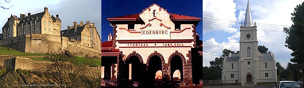
Edenburg was founded on 24 February 1862 when the farm Rietfontein was purchased to build a church. The first application for recognition as a town was turned down by the Volksraad, but proclamation was eventually granted on 4 March 1863. The origin of the name is unclear. The most likely explanation is that it is a reference to the Garden of Eden of the Bible. However, there are those who believe that it is an Afrikaans version of Edinburgh in Scotland.
ACTIVITIES
Berliner Missionary Station: The oldest of its kind in the Free State, located 16km north of the town. Voortrekker Graves: At the Dutch Reformed Church are these 19th century Voortrekker graves. Postal Coach Tracks: Dating back to 21 February 1952. Town Hall: Has been declared a National Monument.
Edenburg Tourism Bureau
Contact details
Loop and Church Street, Edenburg
Tel: (051)743-1658
Fax: (051) 743-1218
FAURESMITH
Overview
Fauresmith is situated approximately 77 km northwest of Trompsburg. Access to the town is gained the R704 route between Koffiefontein and Jagersfontein.
Social and economic functions
Fauresmith/Ipopeng serves as a commercial and social service centre within the Kopanong Municipality. The main social and economic functions of the town is to serve as a (a) general agricultural service centre to surrounding farming areas, and (b) social functions such as residence, education and medical services.
HISTORICAL BACKGROUND
Fauresmith is the second oldest town in the Free State. The name of the town is a combination of the surnames of the Rev Philip Faure, moderator of the Dutch Reformed Church who visited the region in 1848, and Sir Harry Smith, Governor of the Cape Colony. Fauresmith and Bloemfontein were regarded as the two most important towns in the then republic of the Orange Free State. The town lost out to Bloemfontein as the capital city by two votes.
Archaeology and palaeontology
Many implements and artifacts, including stone hand axes and cleavers, dating back to the Early and Middle Stone Ages (35 000 – 50 000 years ago), have been found in the district
HISTORY AND ARCHITECTURE
Battle of Boomplaats
The Battle of Boomplaats between British and Boer troops took place at Jagersfontein, approximately 30 km from Fauresmith. Fauresmith Jail: The jail in Westend Street, a declared National monument, was erected in 1881, and is constructed mostly of stone. Great Trek Monument: The Great Trek Monument is situated on the farm Samar, seven km out of town.
Historic graves
Graves dating back to the 1800s can be viewed in the town’s cemetery where there is also a Burgher Monument commemorating the Boers who lost their lives during the Anglo-Boer War. The graves of approximately 25 British soldiers also lie here but in a different part of the cemetery. The graves of three murderers, executed in public, lie in the open veld about one km outside the town.
Historic Buildings
The Town Hall is a beautiful old Victorian style building completed in 1930. The Dr WH Boshoff Homestead in Oos Burger Street is a typical example of sandstone architecture. The lovely old Standard Bank Building, in Voortrekker Street, was in use right up to 1998 and was then donated to the Dutch Reformed Church. The part of the building known as Die Blou Gallery (“The Blue Gallery”) is presently used as a church hall. The Post Office building was opened in 1905 and the Police Station and Magistrate’s Offices date back to 1936.
Historic Tree
The historic old karee tree (Rhus lancea) dubbed the “Church Tree”, provided the shade under which the town’s first communion service was held on 9 November 1848. Thirty-two members of the Dutch Reformed Congregation took part in this communion service. The tree is located in the centre of the town.
ATTRACTIONS
Railway Line
The most unusual feature of the town is the train which runs twice a day on tracks lying directly through the centre of town. The annual Stream Train Road Race, from Jagersfontein to Fauresmith, attracts hordes of spirited participants and avid supporters.
International Horse Endurance Race
Today, Fauresmith is renowned for the International Horse Endurance Race hosted by the town every July.
For more information
GARIEP DAM
Overview
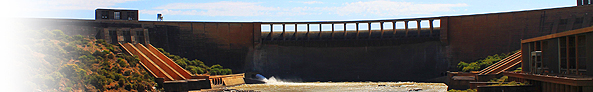
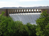
The !Gariep Dam is situated approximately 62 km south of Trompsburg and is the largest expanse of fresh water in the country. It lies on the Orange River, one of the country’s largest rivers, its shoreline extending some 435 kilometres near the towns of Bethulie, Venterstad, Colesberg, Oviston and Aliwal North. The town Gariep Dam, (the youngest town in South Africa) situated alongside the N1, is perhaps better known to most for the manmade Gariep Dam (which is the largest dam in South Africa with a radius of 360 square kilometres) which forms part of the Orange River Development Scheme.
The sheer magnificence of this more than 100km long and 24km wide dam, is indeed sufficient to testify to the exceptional engineering and success of Africa’s largest water supply scheme. The Free State’s largest nature reserve is a combination of the 36 487 ha Gariep Dam on the Orange River and an 11 237 ha game sanctuary on its northern shore. The town’s official status as the Municipality of Verwoerd Dam was proclaimed on 21 April 1994. The name was officially changed on 4 October 1996 to Gariep Dam.
Social and economic functions
The main social and economic functions of the town include: key regional tourist destination, general agricultural service centre to surrounding farming areas, social functions such as residence, education and medical services as well as transport support services on major routes.
Fish Hatchery
The Free State Provincial Government and the People’s Republic of China have embarked on an exciting new project at the !Gariepdam, namely a fish hatchery. China will invest R60 million over three year period. The first phase of the project was launched during October 2009 by the Premier of the Free State, Mr. E.S. Magashule and the Chinese ambassador to South Africa, Zhong Jianhua. The project entails the building of an aqua training and education centre and fish hatchery. Ten aqua tanks – that will eventually grow to 80 – will be used to hatch indiginous fish for the people of the Xhariep district.
Background
The great Orange River project which was started in 1928 gave rise to the Hendrik Verwoerd Dam. The Town and Kampong areas were erected in the early 1960’s. The rural area became known as Oranjekrag and accommodated 3500 people all involved with the construction of the dam wall. The completion date of construction was 31 August 1969
ACTIVITIES
Fish Hatchery
See how Yellow Fish, Carp and Barbel are hatched.
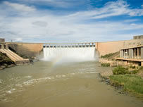
Gariep Dam Wall
Arrange with the Department of Water Affairs for a tour through the dam wall. There are 13 km of passages and halls within the walls of the Gariep Dam. During the yearly water festival, church services and dances are held in the dam wall where up to 400 people are present.
Gariep Nature Reserve
The reserve covers an area of 13 500 ha when the dam is full. Game that you may encounter on the 25 km long tourist roads includes; Black and Blue Wildebeest, Blesbuck, Springbuck, Cape Mountain Zebra, Ostrich, Red Hartebeest, Vaal Rhebuck, Mountain Reedbuck, Duiker and Steenbok
Gariep Power Station
The first hydro-electric power station was built in, Gariep Power Station, by Escom. Tours through the power station can be arranged at 051-7540400.
Norvalspont Concentration Camp
In February 1901, Capt Wynne laid out the Norvalspont concentration camp. The inhabitants received the same rations as in all the other camps established in the period namely: 3/4lb of either mealie meal, rice or potatoes, 1lb of meat twice weekly, 1oz of coffee daily, sugar 2oz daily, and salt ½ oz daily. 366 people died in the camp and the main cause of death was measles.
Shell collection
View this beautiful and outstanding collection of more than 4000 shells at 10 Tinktinkie St.
Gliding
International gliding championships are held annually in December at the airfield. Overseas gliders agree that Gariep Dam is the mecca for gliding competitions to set up world records for gliding.
For more information
JAGERSFONTEIN
Overview
Jagersfontein is situated approximately 67 km northwest of Trompsburg. Access to the town is gained from the R704 route between Fauresmith and Trompsburg.
Social and economic functions
Today Jagersfontein/Itumeleng serves as a commercial and social service centre within the Kopanong Municipality and The main social and economic functions of the town include; (a) diamond mining operations, (b) regional social centre for health services, (c) general agricultural service centre to surrounding farming areas, and (d) social functions such as residence, education and social services.
HISTORICAL BACKGROUND
The town was founded in 1871 with the discovery of the first diamond. The town was named after the original farm, Jagersfontein, once the property of a Griqua, Jacobus Jagers. The Cape Government bought the original farmhouse for use as an office and established what must be one of the most unique gaols in the country, right in front of the house – a Eucalyptus tree trunk to which the prisoners were tied. It was the first town in the Free State to have electricity and a piped water supply. The town was famous for the exceptional quality of diamonds produced. The Jagger jewel diamond found at Jagersfontein was famous for the exceptional quality. The Excelsior diamond, at 972 carats one of the ten biggest diamonds ever found in the world, came from this mine (1893). Until the discovery of the Cullinan Diamond near Pretoria (1905), it was also the largest white diamond ever to be found. In present day terms the value of the Excelsior is estimated at R1, 2 billion.
Two years later in 1895 another white of 640 carats and of similar quality was found and named the Reitz. Later this stone was renamed the Jubilee. The Jagersfontein of old was a typical mining town of it’s time and it offered all the pleasures and joys of similar towns elsewhere in the world. It had five big hotels and 34 bars, shops and businesses of all Orange Free State. After 34 years of open pit mining, underground mining by means of a vertical shaft and horizontal tunnels (drifts) started in 1913. During the 100 year life span of the mine, several stoppages occurred for example during the two World Wars and the great depression. During this time Jagersfontein’s mine produced 9,625 million carats of diamonds, mostly of jewel quality. It is estimated that due to inefficient mining methods of the past, a large proportion of diamonds from this pipe were never recovered.
HISTORY AND ARCHITECTURE
Battlefield sites
The Battle of Boomplaats took place on 29 August 1848 in the vicinity of the town. This battle, fought to reassert British authority in the area known as the Orange River Sovereignty, cost the British dearly even though they did manage to achieve their goal. The British subsequently erected a monument commemorating and naming those who died here. Also visit the Swartkoppies Battlefield site, situated on the Farm Swartkoppies, in the district.
Historic Churches
The beautiful old Roman Catholic Church was built in 1881 and features exquisite original paintings depicting the stages of the cross as well as a beautiful baptismal font. Both the Dutch Reformed and Methodist Churches were built in 1881, the Anglican Church being erected ten years later, in 1891.
Historic Buildings
The town boasts no less than five buildings that were designed by the renowned architect Sir Herbert Baker. These buildings are the Town Hall, the Standard Bank Building and the building next to it, the old Barclays Bank Building and the Dutch Reformed Church. Jagersfontein also has the second oldest Masonic lodge in South Africa.
Old Mine and Mining Village
Although active mining has long since ceased in Jagersfontein the mine that originally heralded in the diamond rush still exists. The historical mining village in Meteor Street bears testimony to the town’s mining history. An interesting recent development is the recovery of diamonds from old mine dumps.
Open Mine: The Open Mine (“Big Hole”) has a handy lookout post nearby, and the Open Mine Museum offers an overview of the town’s origin and mining history. MOTH Museum: This Museum, known as the “Monte Sole Shell Hole”, exhibits memorabilia and other old and precious items from the Boer Wars, the First and Second World Wars and the more recent war waged on the northern borders of the former South West Africa (Namibia). Sun Street: Sun Street, in Itumeleng, is one of the town’s oldest streets. Water pumps: The quaint, original old water pumps, installed in 1913, yielded three gallons of water per penny and are still standing. Jagersfontein was the first town in the province to deliver fresh water to its community via a piped system.
PHILIPPOLIS
Overview
Philippolis/Poding-tse-Rolo serves a general agricultural service centre within the Kopanong Municipality and is situated approximately 53 km southwest of Trompsburg. Access to the town is gained from the R48 route between Koffiefontein and De Aar.
Social and economic functions
The main social and economic function of the town is to serve as (a) key regional tourist destination, (b) secondary agricultural service centre, and (c) social functions such as residence, education and medical services.
HISTORICAL BACKGROUND
Phillipolis is the oldest town in the Free State. Philippolis was first established in 1823 as a mission station of the London Missionary Society for San/Khoi-Khoi (later to be known as Griquas) people. It is the oldest settlement in the Free State. Adam Kok, the famous Griqua leader, and his people settled in the area in 1826 and he was subsequently appointed protector of the mission. When the government of the Orange Free State bought the land, Adam Kok and his people left to start a new life in Griqualand East. Dr. John Philip was the London Missionary Society’s representative, hence the name of the town that was later established here. The renowned author, Laurens van der Post, who grew up in this town, described the area with its vast open spaces as “puritanical hills guarding secret water, so that it appears totally unpeopled.”
ARCHAEOLOGY AND PALAEONTOLOGY
Fossil Finds
The Phillippolis area is renowned for its rich fossil finds. The recent discoveries of a fossilised fish thought to have become extinct 240 million years ago, a fossilised fish bed, reptile fossils and various fossilised footprints again prove that, impossible as it may seem, this area was once located at the bottom of a large lake.
Rock Art
There are various San rock paintings in the area.
HISTORY AND ARCHITECTURE
Adam Kok House
Adam Kok House, sometimes referred to as Griqua House, was once the home of the famous Griqua leader, Adam Kok.
Dutch Reformed Church
The Dutch Reformed Church, situated in Voortrekker Street, has been declared a national monument. The historic pulpit is carved out of wild olive wood.
Emily Hobhouse Spinning and Weaving School
Emily Hobhouse, the famous British humanitarian, choose Phillippolis as the location of a spinning and weaving school to help impoverished Boer women after the Anglo-Boer War. Exhibits from the school are on view at the TransXhariep Museum.
Phillippolis Jail
The old jail, built in 1872, has been lovingly restored and turned into a guest house. Enjoy a voluntary stay in one of the individual 2 x 3 m cells safely ensconced behind the jail’s 45 cm thick inner walls and 60 cm thick outer walls, secure in the knowledge that you may leave in the morning. Several married couples have started their marriage in an unconventional way by staying in the honeymoon suite at the jail. For those scared of small spaces, more conventional facilities are also available.
Historic Buildings
There are several historic buildings in and around the town, such as the Van der Post and Van Rensburg houses, as well as some typical flat-roofed Karoo houses.
TransXhariep Museum
The TransXhariep Museum in Voortrekker Street depicts the history of the town and its people. Two historic cannons used by the Griquas can be viewed on a hillock behind the museum.
Van der Post House and Memorial Garden
The ashes of Sir Laurens Jan van der Post, world-renowned South African author, war hero and naturalist, are kept in the Van der Post Memorial Garden. The garden, created by design architect, Alida Stewart, has as its central theme “life as a journey”; the philosophy heralded by Van der Post all through his life. The Sir Laurens van der Post Artist Retreat Centre is also located here and is a retreat where artists, writers, photographers and other creative people can unwind and seek new inspiration. The small museum, also part of the complex, keeps copies of his 25 books and the desk at which he used to write.
Tiger Canyons
John Varty (JV) is a South African conservationist and filmmaker who specializes in Big Cats. JV established Tiger Canyons near the town of Philippolis on the Van der Kloof Lake in the Karoo of South Africa as an experiment to create a free-ranging, self-sustaining tiger population outside Asia. From this population, third and fourth generations of tigers can be returned to Asia into parks that meet a set of criteria which give the tigers a chance of surviving in Asia. He successfully introduced a lion cub into a tiger litter to test if a tigress would adopt a cub which is not their own. This way genetic diversity can be increased in populations of wild tigers where inbreeding is occurring.
MORE INFORMATION
REDDERSBURG
Overview
Reddersburg is situated approximately 65 km northeast of Trompsburg. Access to the town is gained from the R717 route between Edenburg and Dewetsdorp.
Social and economic functions
Reddersburg/ Matoporong serves as a general agricultural service centre within the Kopanong Municipality. and The main social and economic functions of the town is to serve as (a) general agricultural service centre to surrounding farming areas, and (b) social functions such as residence, education and medical services.
HISTORICAL BACKGROUND
The town was founded by the Dutch Reformed Church when the farm Vlakfontein was bought for 1500 pounds on 20 August 1859 for a parish and named ‘Saviour’s Fort’, a town well known for strict moral laws. Until 1894, when the municipality took over, the town was run by the church. Among the bylaws was a prohibition of profane language and disturbances of the peace. Those who fell afoul of these regulations were given eight days to leave town. It was in Reddersburg that the legendary General Christiaan de Wet (1854 – 1922) made his final public appearance in 1922.
ATTRACTIONS
Obelisk: Commemorating General de Wet (1854 – 1922), the Boer general who captured an entire British column at Reddersburg during the Anglo-Boer War. Anglo-Boer War Memorial: Dedicated in particular to fallen soldiers from the Reddersburg district. Civic Monument: A commemoration of Boer victims of the Anglo-Boer War. Mosterthoek Battlefield: The Boers overwhelmed the British forces and on 4 April the white flag was hoisted here. Reformed and Dutch Reformed Churches: Two sandstone churches grace the town centre. In one of them an Anglo-Boer War powder magazine can be seen. Republic Monument: A monument originally erected to commemorate the country becoming a republic.
The Reddersburg Tourism Bureau can be contacted at (051) 553-0011.
SPRINGFONTEIN
Overview
Springfontein/ Maphodi is situated 150km south-west of Bloemfontein on the N1 and approximately 22 km south of Trompsburg. Access to the town is gained from N1 route between Bloemfontein and Colesberg…
Social and economic functions
The main social and economical functions of the town is to serve as (a) general agricultural service centre to surrounding farming areas, (b) social functions such as residence, education and medical services, and (c) transport support services on major route. Springfontein is an important railway junction. The lines from Port Elizabeth and East London to Gauteng converge here while another line runs west to the diamond-producing town of Koffiefontein via Jagersfontein and Fauresmith.
HISTORICAL BACKGROUND
The town derives its name from a strong artesian spring on the farm Springfontein. Hartleydale, part of this farm, was chosen as the site for the new village in 1904. Municipal status was granted in 1912.
ARCHAEOLOGY AND PALAEONTOLOGY
San Rock Art: The San petroglyphs (engravings) in the area date back approximately 1 000 years.
HISTORY AND ARCHITECTURE
Anglo-Boer War Blockhouses
Little remains but the foundations of the British blockhouses built next to the railway line during the Anglo-Boer War.
Anglo-Boer War Concentration Camp
The Anglo-Boer War concentration camp was established east of town. In 1901 it was hit by a heavy snowstorm that severely damaged the already flimsy tents that housed the women and children. The death rate in this camp was particularly high: a total of 704 people, mainly children, having died here. Concentration Camp Cemetery: More than 700 Boer and 300 British casualties of the Anglo-Boer War lie buried in the Concentration Camp Cemetery, together with the other casualties of war. Child victims of the concentration camp who were not baptized lie buried in a separate cemetery.
De Bome House
Emily Hobhouse stayed over in the De Bome house on her visits to Springfontein. Her humanitarian work in the concentration camps necessitated regular visits to the town.
Great Trek Memorials
Memorials and Ox Wagon Tracks, commemorate the centenary celebrations of the Great Trek of 1838.
Historic Washing Stone
The original washing stone used by inmates of the concentration camp, now a monument, serves as a reminder of the awful conditions that Boer women and children suffered in the camp.
TROMPSGURG / MADIKGETLA
Overview
Trompsburg/Madikgetla serves as the regional administrative seat within Kopanong. The town is situated approximately 108 km south of Bloemfontein. Access to the town is via the N1 between Bloemfontein and Colesberg.
Social and economic functions
The main social and economic functions of the town include: (a) main local municipal administrative centre, (b) regional agricultural services centre, (c) regional social centre for health services, (d) social functions such as residence, education and social development services, and (e) transport support services on major route.
HISTORICAL BACKGROUND
When the railway from the south reached this area in 1891, Trompsburg was laid out on the farm Middelwater which belonged to Jan and Bastiaan Tromp. Initially the town was known as Jagersfontein Road, before the branch railway was built from Springfontein to Koffiefontein via Jagersfontein. Later it was named Hamilton after Sir Hamilton J. Goold-Adams, governor of the Orange River Colony from 1902 to 1910. Still later the name was changed to Trompsburg in honour of the owners of the farm. The town was granted municipal status in 1902.
Arts and crafts
Arts and crafts; includes; woodwork, needlework, soap and paper sculptures.
HISTORY AND ARCHITECTURE
Boomplaas Battlefield: The Boomplaas Battlefield site is situated some 24 km north-west of the town, along the Jagersfontein Road. Great Trek Centenary: An obelisk in the main street commemorates the centenary celebrations of the Voortrekker Great Trek that took place in 1838. Shearing Barn: The country’s second largest shearing barn is situated near town.Scale-model firearms: Meticulous scale models of historical firearms, made by Gert Steyn, can be seen on the farm Boesmansfontein. Stone Wall: An 11-km stone wall built by hand, can be seen in the vicinity of town.
The Trompsburg Tourism Bureau can be contacted at (051) 447-1362.