- Free State Online
- Departments
- Office of the Premier
- Agriculture & Rural Development
- Education
- Health
- Coorporative Governance & Traditional Affairs
- Public Works & Infrastructure
- Police, Roads & Transport
- Social Development
- Sport, Art, Culture and Recreation
- Economic, Small Business Development, Tourism & Environmental Affairs
- Human Settlements
- Treasury
- Municipalities
- Entities
Profile of the Municipality
Overview
The Kopanong Municipal area is situated in the southern Free State. It has the largest surface area of the three local municipalities in the Xhariep district, covering 15 190 square kilometres (44, 5%). Nine towns form part of Kopanong.
Trompsburg (Municipal Head Office)
Trompsburg/Madikgetla serves as the regional administrative seat within Kopanong. It is situated approximately 108 km south of Bloemfontein. Trompsburg is named after Jan and Sebastiaan Tromp, owners of the farm Middelwater on which the town was founded in 1891. It is a small agricultural town and one of Free State’s best Marino sheep product manufacturers. The town lies in a cove between small hills and has the 2nd largest shearing barn in South Africa.

Initially the town was known as Jagersfontein Road, before the branch railway was built from Springfontein to Koffiefontein via Jagersfontein. Later it was named Hamilton after Sir Hamilton J. Goold-Adams, governor of the Orange River Colony from 1902 – 1910. Still later the name was changed to Trompsburg in honour of the owners of the farm on which the town is built.

Various activities abound for the outdoor enthusiast. These include bird watching, freshwater fishing, hiking, walking, game viewing and horse riding.
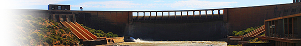
Gariep Dam
The Gariep Dam is situated approximately 62 km south of Trompsburg and is the largest expanse of fresh water in the country. It lies on the Orange River, one of the country’s largest rivers, its shoreline extending some 435 kilometres near the towns of Bethulie, Venterstad, Colesberg, Oviston and Aliwal North. The Free State’s largest nature reserve is a combination of the 36 487 ha Gariep Dam on the Orange River and an 11 237 ha game sanctuary on its northern shore.

From the dam some 200 000 ha of land is irrigated, by means of a tunnel of 83,8 km, delivering water to the upper valleys of the Fish River, and then from another 13,2 km tunnel to the Sundays River. The dam covers some 374 square kilometers. With the supply of some 455 million litres of water to the dry Karoo region around it, the hydro electric scheme generates 600 000 kilowatts of power, as well.
The dam was officially opened in 1972 and is very popular with both anglers and boating enthusiasts. Water sports and attractions include sailing, power boating, canoeing, skiing, angling and sporting. The game reserve accommodates the largest population of springbok in any reserve in the country and also features Cape mountain zebra, klipspringer, black wildebeest, red hartebeest and ostrich. The main social and economic functions of the town includes; key regional tourist destination, general agricultural service centre to surrounding farming areas, social functions such as residence, education and medical services as well as transport support services on major routes.
Fish Hatchery
The Free State Provincial Government and the People’s Republic of China have embarked on an exciting new project at the Gariep Dam, namely a fish hatchery. China will invest R60 million over three year period. The first phase of the project was launched during October 2009 by the Premier of the Free State, Mr. E.S. Magashule and the Chinese ambassador to South Africa, Zhong Jianhua. The project entails the building of an aqua training and education centre and fish hatchery. Ten aqua tanks – that will eventually grow to 80 – will be used to hatch indiginous fish for the people of the Xhariep district. During the first phase, it is estimated that 580 job opportunities will be created for local people. Upon completion of the project, it is estimated that 105 full-time jobs will be created.
Forever Resorts Xhariep

The Resort is situated on the banks of Gariep Dam, the largest dam in South Africa and bordering the Gariep Dam Nature Reserve, home to many species of antelope and the Cape Mountain Zebra. Accommodation consists of 44 two or three bedroom chalets and 12 luxury one or two bedroom chalets. The three star Caravan Park has 106 sites all with power and serviced by two ablution facilities. 16 of the luxury caravan sites have their own ablution facility. The resort offers three conference facilities that can accommodate between 12 to 300 delegates.
Springfontein
Springfontein is situated 150km south-west of Bloemfontein on the N1. The town derives its name from a strong artesian spring on the farm Springfontein. Hartleydale, part of this farm, was chosen as the site for the new village in 1904. Municipal status was granted in 1912. This town’s history relates directly to the struggle, and especially to the hardships, of the Anglo-Boer War. Springfontein is an important railway junction. The lines from Port Elizabeth and East London to Gauteng converge here while another line runs west to the diamond-producing town of Koffiefontein via Jagersfontein and Fauresmith.
Springfontein/Maphodi serves as a general agricultural service centre within Kopanong. It is situated approximately 22 km south of Trompsburg. Access to the town is via the N1 between Bloemfontein and Colesberg. The main social and economic functions of the town include: general agricultural service centre to surrounding farming areas, social functions such as residence, education and medical services and transport support services on major routes.
Some of the historical sites in the town include the concentration camp and concentration camp cemeteries. The concentration camp was situated east of the town. During 1901 it was hit by a heavy snowstorm and many of the tents were damaged. Due to the severe winter the death rate were high in the camp. A total of 704 people, mainly children, died in the concentration camp. The graves of over 700 Boer and British victims of the Anglo-Boer War are buried in the same cemetery.
Bethulie
Bethulie/Lephoi serves as a regional agricultural service centre within Kopanong. It is situated approximately 52 km south of Trompsburg. Access to the town is via the R701 between Gariep Dam and Smtihfield. The main social and economic functions of the town include: regional agricultural services centre, key regional tourist destination and social functions such as residence, education and medical services.
Formerly a Mission Station, this town has great historical significance and many outdoor attractions that will appeal to any visitor. During the Anglo-Boer War, (1899 to 1902) the largest concentration camp erected by the British was situated in Bethulie. The cemetery displays small sandstone graves of deceased concentration camp children to the silver crosses at the heads of soldiers’ graves. A large memorial, built on the outskirts of town, with name walls will have you linking a trace to the many nationalities once engulfed in the duress of the Anglo Boer War.